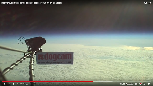
This is the edited version posted by the "dogcam" account on YouTube:
There are two cameras on-board. One of them is a Fish-Eye lens and the other is, at least, fairly rectilinear. I will ONLY be discussing the images from the non-fish-eye, rectilinear camera -- and we can tell it is fairly low distortion both by comparing the lower-altitude images with the higher altitude images and by looking for changes in the shape of the horizon curvature (the curvilinear "Fish-Eye" lens warps the horizon different amounts depending on where it crosses the lens).
At the 4:13 mark we can see the Time is 0711 hours, Altitude 23,800 meters at 106 minutes into the flight - and about 14 seconds later we can see the "Hotspot" that has Flat Earthers all hot and bothered -- as the aptly named p-brane muses:
 |
| Figure 1. comment by p-brane |
 |
| Figure 2. dogcam footage 4:27 showing "Hotspot" |
SURELY, this time we will prove a "Nearby Sun" -- right? Well, once we reach maximum altitude we are treated to this view...
 |
| Figure 3. 1080p frame from dogcam with curvature highlighted, near max altitude |
The first glaring error in p-brane's statement is that the CLOUDS are doing anything. It's not reflecting off the clouds, the clouds cleared away (you can compare with earlier footage) and exposed the Baltic Sea.
From here we should be done -- the Ocean surface is wavy and reflections simply work this way.
 |
| Figure 4. How Reflections Work |
But we can take this one step further and ask -- where WAS the sun at this time?
Was it indeed over the Baltic Sea shining down like a "Spot Light" and creating a hotspot like a lamp?
Let's verify our location first, looking at 7:14 mark we can see more of the land & water:
 |
| Figure 5. dogcam 7:14 mark looking East to Swinoujscie, Poland |
We can see Swinoujscie, Poland (which is just over the border) off in the distance which is East of Wasbek, Germany.
 |
| Figure 6. Google Earth view showing Wasbek and Swinoujscie |
 |
| Figure 7. Google Maps view of Swinoujscie |
We can convert this into a mask:
 |
| Figure 8. Mask of Swinoujscie Area |
and rotate (North is the top of the Google Map and to the Left in our Dogcam image since we are looking East), shrink, and overlay it with our image from 7:14 (you can view an animated version of this in Sly's analysis video).
 |
| Figure 9. Overlay of Swinoujscie area and Dogcam footage. |
Ok, so we know we're over Wasbek, Germany on April 19th, 2011 looking East at around 0711 hours, Swinoujscie is roughly 160km away and the reflections we are seeing are off the water.
Final piece of the Puzzle, was the Sun anywhere NEAR Swinoujscie at 0711 hours?
 |
| Figure 10. Sun location at 0711 hours: Latitude: 11° 03' N, Longitude: 102° 19' E |
So riddle me this... How is the Sun directly over a spot about 9000 km away from the "Hotspot"?
 |
| Figure 11. Google Earth view of where the Sun was overhead (9000km away) |
This is exactly what we would expect on a Globe.
So we have clear evidence of curvature and we have the data to show a local "Hotspot" is an absurd concept that some Flat Earther just pulled out of their arse.
Other Questions
Did the sun get bigger?
No, unless you properly expose the Sun you simply CANNOT judge the size in an image.
I have more than amply demonstrated that multiple times and in multiple ways.
 |
| Figure 12. Sun doesn't change size, you have to expose it properly to measure it |
Is the sun huge at high-altitude?
No, it's all lens flare, sensor bleed, another other optical effect, you cannot see the size of the Sun in this video except in a few spots where the internal reflections give it away.
Why don't we see the Earth rotating?
Because the balloon is moving with the Earth -- it's called Inertia, do your research.
Why doesn't the balloon land a billion miles away from the launch site?
Because the balloon is moving with the Earth -- it's called Inertia, do your research.
More Information
I also highly recommend watching Sly's beatdown video:

No comments:
Post a Comment
Note: Only a member of this blog may post a comment.